Aerial Imaging & Site Documentation
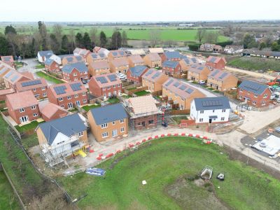
Aerial photography, panoramas and visual site surveys
We provide high-quality aerial imagery and site documentation for property, construction and infrastructure clients — from single-property photography to ongoing site monitoring.
Clear aerial imagery for property and site professionals
Dragonfly Surveys captures aerial imagery for a range of commercial applications — whether you need photography for a property listing, a visual record of a construction site, or roof and structure imagery for maintenance planning. We work to your brief and deliver clear, well-organised outputs.
Our Services

Aerial Photography
Roof & Structure Imagery
360-Degree Panoramas
High-resolution aerial photographs for property marketing, estate documentation, land management and commercial projects. Images are captured to your brief and supplied as organised, edited files in agreed formats.
360-Degree Panoramas
Roof & Structure Imagery
360-Degree Panoramas
Immersive aerial panoramas provide a wider view of a property or site from a single viewpoint. Suitable for site records, estate documentation and presentations, panoramas can be supplied as interactive images or static exports, depending on your requirements.
Roof & Structure Imagery
Roof & Structure Imagery
Roof & Structure Imagery
Drone imagery provides a safe and efficient way to capture detailed visuals of roofs, gutters, chimneys and other elevated structures — without the need for scaffolding or access equipment. Useful for maintenance planning, insurance documentation and condition records. We provide imagery only; structural assessment is outside our scope.